Table of Contents
Hurricane Milton Landfall Expected Tonight: Florida Braces for Catastrophic Storm Surge, Winds, and Flooding
October 9, 2024 – Florida is bracing for the devastating impact of Hurricane Milton, a powerful Category 4 storm set to make landfall tonight. The hurricane poses a severe threat to life and property, with forecasts predicting deadly storm surges, destructive winds, and widespread flooding across the state. Residents in vulnerable areas have been urged to complete preparations immediately.
01
of 07Hurricane Milton’s Current Path
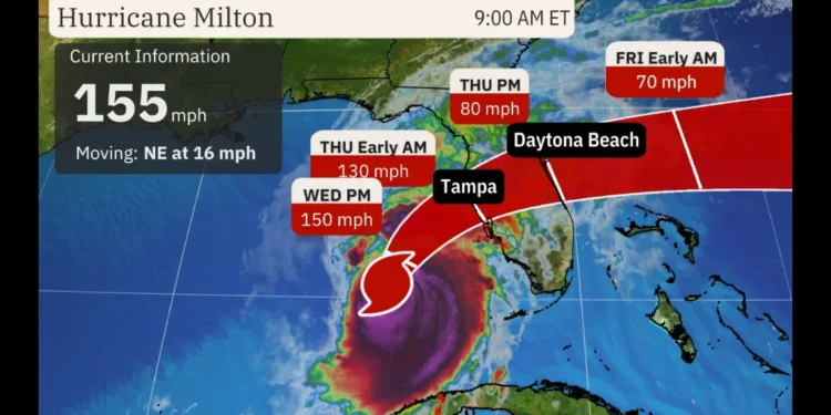
As of this morning, Hurricane Milton is packing sustained winds of up to 155 mph and is located approximately 250 miles southwest of Tampa. The storm is moving northeast at a steady 16 mph and is expected to make landfall along Florida’s Gulf Coast late Wednesday into early Thursday.

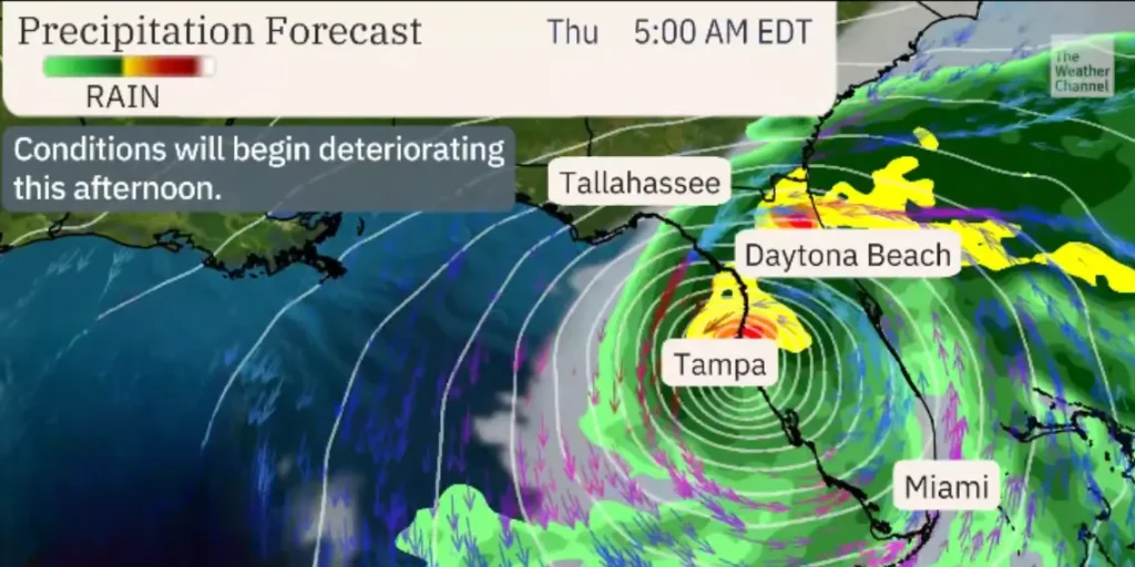
The National Weather Service has warned that the Tampa Bay region and surrounding areas face the worst-case scenario, with Milton’s projected path expected to bring severe flooding, structural damage, and potential tornadoes. The sheer size of the hurricane, with tropical storm-force winds extending 125 miles from its center, means its destructive impacts will be felt across a large portion of the state.
02
of 07Storm Surge and Flooding Concerns
The most life-threatening aspect of Hurricane Milton is the storm surge, predicted to reach between 8 and 15 feet along parts of the west-central Florida coast, including Tampa Bay and Charlotte Harbor. According to the latest forecast from the National Hurricane Center, this surge could be the highest seen in Tampa Bay in more than a century, particularly if it coincides with the high tide on Thursday morning.
A storm surge warning is in effect for much of Florida’s Gulf Coast, from Flamingo to Yankeetown, as well as parts of the Atlantic coastline stretching from Sebastian Inlet to Georgia’s Altamaha Sound. Officials have urged residents in storm surge-prone areas to follow evacuation orders immediately to avoid potentially deadly flooding.
03
of 07Wind and Power Outages
In addition to the storm surge, Hurricane Milton’s devastating winds are expected to cause widespread damage, particularly in central Florida. Communities from Tampa to Orlando and Cape Canaveral will likely experience wind damage, downed trees, and power outages that could last for days.
The most severe wind damage is anticipated where the center of Milton crosses the coast. The destructive winds, capable of structural damage, are forecast to arrive late Wednesday along the western Gulf Coast and spread eastward across central Florida through Thursday.
04
of 07Rainfall and Tornado Threat
Along with the dangerous winds, Milton will also bring torrential rain and a high risk of flooding. Rainfall totals across central and northern Florida are expected to range between 6 and 12 inches, with localized areas possibly receiving up to 18 inches. The National Oceanic and Atmospheric Administration (NOAA) has issued a high-risk flood warning for central Florida, including the Tampa Bay and Orlando areas, due to the expected heavy rainfall.

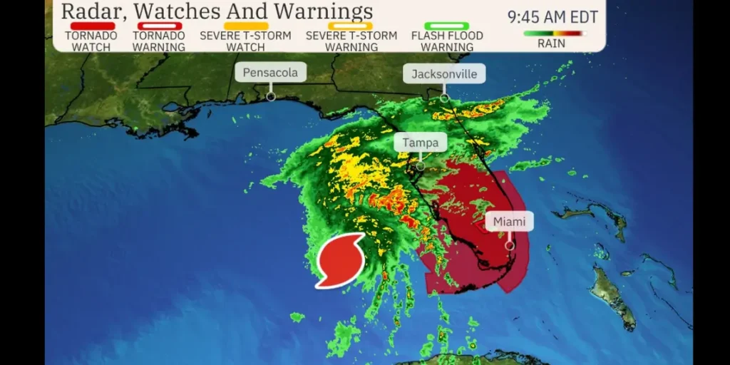
Tornadoes are another significant threat from Milton, with several forecasts that they will hit the southern and central parts of the state today and tonight. A tornado watch is currently in effect until 9 p.m. EDT for regions including Miami, Tampa Bay, and Fort Myers.
05
of 07Beyond Florida: Regional Impact
The destructive force of Hurricane Milton will not be confined to Florida. Tropical storm warnings have been issued for parts of Georgia, South Carolina, and North Carolina, which may experience strong winds, coastal flooding, and isolated tornadoes as Milton moves inland.
06
of 07Rapid Intensification of Hurricane Milton
Hurricane Milton has shown remarkable intensification since forming as a tropical depression in the Gulf of Mexico on October 5. By October 7, the storm’s winds had increased to a staggering 180 mph, placing Milton among the most powerful hurricanes in Atlantic history. Its central pressure dropped to 897 millibars, the fifth-lowest ever recorded in the Atlantic, making it the most intense hurricane since Wilma in 2005.
07
of 07Evacuation and Safety Recommendations
As Hurricane Milton approaches, authorities have emphasized the importance of completing evacuations and storm preparations. The National Weather Service has cautioned that even if the hurricane weakens slightly before landfall, the impacts will still be severe. Storm surge, wind damage, and flooding will affect a vast area, and residents should not let their guard down.
Local officials are urging those in the storm’s path to evacuate immediately and to heed all safety protocols. Power outages, transportation disruption, and damage to homes and infrastructure are expected across Florida.
For up-to-date information on Hurricane Milton’s path and official safety guidelines, follow updates from the National Hurricane Center and local authorities.
This comprehensive update is based on the latest report from Weather.com, citing Jonathan Belles, Chris Dolce, Caitlin Kaiser, and Sara Tonks. For more on this developing situation, stay connected to Unitedpac St. Lucia News for further updates.


