


Fair skies persist in St Lucia as forecasters issue Erin storm update for the weekend
CASTRIES, St Lucia, – The Saint Lucia Meteorological Services has issued a fresh Erin storm update as the system moves westward across the Atlantic, with the tropical storm expected to approach the northern Leeward Islands over the weekend.
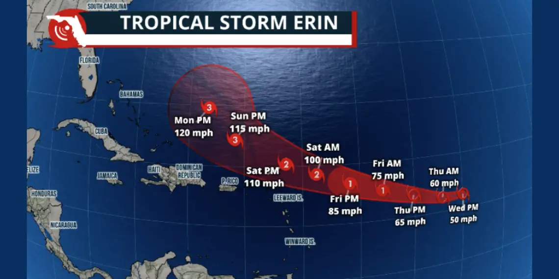
At 11 a.m., Tropical Storm Erin was centered near latitude 16.4 North, longitude 49.7 West, approximately 771 miles (1,240 km) east-northeast of St Lucia, forecaster Lucious Frederick reported in Thursday’s midday weather briefing. The storm is moving west at 17 mph (28 km/h) and is forecast to turn west-northwest tonight, maintaining that motion into the weekend.
On its current track, Erin’s center is likely to pass near or just north of the northern Leeward Islands. Residents in those areas are being advised to monitor the storm’s progress closely. Additional background on the system’s development can be found in Unitedpac St Lucia News’ earlier report.
Fair skies persist in St Lucia as forecasters issue Erin storm update for the weekend
Local weather remained stable at midday, with fair skies at Hewanorra International Airport and partly cloudy conditions at George F. L. Charles Airport. Temperatures at Hewanorra reached 31°C (88°F), with a relative humidity of 71 percent. Winds were from the east-southeast at 15 mph (24 km/h).
Rainfall over the past 24 hours totaled 6.1 millimeters at Hewanorra and 6.7 millimeters at George F. L. Charles. For August so far, cumulative totals stand at 53.4 millimeters in the south and 29 millimeters in the north.
The forecast for the next 24 hours calls for fair skies becoming cloudy at times with a few showers and a slight chance of thunderstorms. Winds will shift between east and east-southeast at around 14 mph (22 km/h), becoming lighter at intervals.
Marine conditions remain slight to moderate
Seas within a 25-mile (40-km) radius of St Lucia are expected to be slight to moderate, with wave heights ranging from 3 to 5 feet (0.9 to 1.5 meters).
Tidal patterns today include a low tide at 12:39 p.m. and high tide at 7:14 p.m. for Castries Harbour, and a low tide at 2:06 p.m. followed by high tide at 8:21 p.m. for Vieux Fort Bay.
Regional forecast and tropical activity
Across the Lesser Antilles, skies will be mostly fair, becoming occasionally cloudy with showers and a chance of isolated thunderstorms.
A weak tropical wave is also expected to bring periods of cloudiness and scattered showers to both the northern and southern Lesser Antilles, with possible isolated thunderstorms in southern areas this afternoon.
In addition, a separate tropical wave over the far eastern tropical Atlantic is moving westward at about 15 mph (24 km/h).
For continued coverage of this and other top stories, follow Unitedpac St Lucia News.


