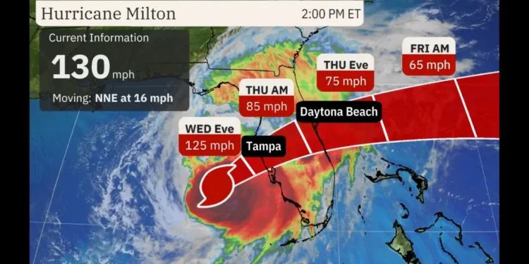
Florida braces as Hurricane Milton 2 PM Forecast warns of destructive winds, tornadoes, and storm surge.
October 9, 2024, 2:00 PM EDT – Hurricane Milton 2 PM Forecast confirms the powerful Category 4 storm is nearing Florida, packing sustained winds of 130 mph. As of 2:00 PM EDT, Hurricane Milton is located 150 miles southwest of Tampa, moving northeast at 16 mph. Heavy rain and strong wind gusts are already impacting parts of the state ahead of its expected landfall later tonight.
Tornadoes Already Impacting Southern Florida
Matlacha Currently. pic.twitter.com/NdJ9dMSUhd
— Carmine Marceno – Florida’s Law and Order Sheriff (@SheriffLeeFL) October 9, 2024
The National Weather Service has issued a tornado watch for the southern half of the Florida Peninsula, including Miami, Tampa Bay, and Fort Myers, lasting until 9:00 PM EDT. Several tornadoes have already been confirmed in southern Florida, contributing to the dangerous conditions the state is currently experiencing.
Heavy Rain and Strong Winds Spreading Across Florida
Hurricane Milton’s outer rain bands are spreading across Florida, delivering heavy rainfall and strong wind gusts to areas far ahead of the hurricane’s center. These weather conditions are expected to intensify as Milton moves closer to landfall.
Hurricane Warnings and Flooding Threats
Hurricane warnings remain in place for much of central Florida, including key cities such as Tampa, Orlando, and Cape Canaveral. With Milton’s winds of 130 mph and its trajectory toward Florida’s Gulf Coast, the combination of deadly storm surge, destructive winds, and potentially life-threatening flooding will impact the state well into Thursday.
The risk of flash flooding and river flooding is also a major concern, especially in central Florida, where the National Weather Service has issued flood warnings.
Urgent Evacuation Warnings
Officials continue to stress the importance of evacuating areas at risk for storm surges and tornadoes. This is a life-threatening situation, and those in hurricane and tornado-prone areas should complete preparations immediately.
Florida Governor Ron DeSantis reiterated earlier today, “Hurricane Milton is still a significant and dangerous threat. Please heed all warnings and evacuate if necessary.”
Hurricane Milton’s Forecast and Path
Hurricane Milton is expected to make landfall late tonight or early Thursday as it continues its track toward Florida’s Gulf Coast. While the storm has weakened slightly, it remains a Category 4 hurricane capable of widespread destruction. The storm surge is predicted to reach between 8 and 15 feet in some areas, including Tampa Bay and Charlotte Harbor, where flooding could become severe.
Prepare for Extended Power Outages
As the hurricane approaches, power outages are expected to occur across central Florida and could last for days. Residents are urged to stock up on supplies and stay indoors during the height of the storm.
Looking Ahead
Hurricane Milton’s impacts will be felt throughout Florida well into Thursday, with its destructive winds, flooding, and tornado threats posing significant risks to life and property. Stay tuned to Unitedpac St. Lucia News for the latest updates as this dangerous storm progresses.
This update is based on the latest report from Weather.com, citing Jonathan Belles, Chris Dolce, Caitlin Kaiser, and Sara Tonks. Further information on the ongoing tornadoes in southern Florida can be found in Weather.com’s coverage here.


