Table of Contents
Hurricane Milton Advisory 5 PM warns of deadly storm surge, tornadoes, and flash flooding as the Category 4 storm nears Florida’s coast.
October 9, 2024, 5:00 PM EDT – The latest advisory from the National Hurricane Center (NHC) indicates that Hurricane Milton continues to pose an extreme threat to Florida as it nears landfall. Currently a Category 4 hurricane, Milton is expected to bring life-threatening storm surges, powerful winds, and the risk of tornadoes and flash flooding across the Florida Peninsula. Residents have been urged to finalize preparations and evacuate where ordered.
01
of 04Key Highlights from the 5 PM Advisory
- Destructive Storm Surge Expected
A massive storm surge is forecast along portions of the west-central coast of Florida, with water levels rising 10 feet or higher in some areas. This surge will be accompanied by damaging waves, and coastal residents should anticipate rapid water level increases as the hurricane approaches. Areas like Tampa Bay and Charlotte Harbor are at significant risk, where the combination of strong onshore winds and the eye of the storm is expected to cause dangerous inundations. - Hurricane-Force Winds to Batter Florida
Devastating hurricane-force winds are expected along Florida’s west coast tonight and into early Thursday, with gusts strong enough to cause widespread structural damage, downed power lines, and fallen trees. The NHC warns that these powerful winds will extend across the peninsula, impacting both the Gulf and Atlantic coasts. Residents in the Hurricane Warning area have been urged to take shelter immediately and stay away from windows as the storm makes landfall. - Tornadoes a Major Risk
The risk of tornadoes continues to threaten southern and central Florida. Several tornadoes have already been confirmed throughout the day, and the tornado watch remains in effect for the Florida Peninsula until 9:00 PM EDT. These tornadoes can occur rapidly and with little warning, further increasing the threat to life and property. Residents in affected areas should be ready to take shelter in an interior room or storm-safe location. - Flash Flooding and River Flooding Likely
In addition to the storm surge, heavy rainfall is forecast to cause catastrophic flash flooding across central and southern Florida. Life-threatening flash floods could occur as rain bands from Milton bring heavy downpours through Thursday, with the possibility of river flooding in inland areas. The combination of coastal and inland flooding is expected to escalate the overall flood threat, impacting transportation routes and low-lying communities.
02
of 04Evacuations and Preparations
Florida officials have reiterated the importance of evacuating areas at risk for storm surges, flash flooding, and tornadoes. The NHC has emphasized that this is a life-threatening situation, and all evacuation orders should be taken seriously. If you live in an evacuation zone, you must leave immediately to avoid being caught in hazardous conditions.
03
of 04Hurricane Milton’s Path and Forecast
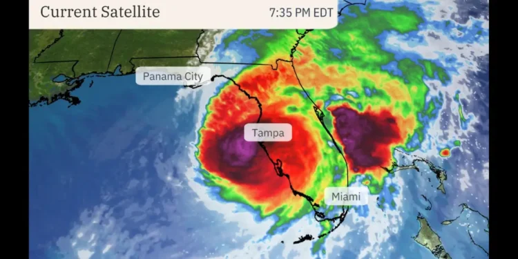
As of 5 PM, Hurricane Milton remains a Category 4 hurricane with sustained winds of 130 mph. The storm is located southwest of Tampa and is moving northeast, with landfall expected along the west-central Florida coast later tonight. The current path indicates that Milton will bring its most severe impacts to areas from Tampa to Charlotte Harbor, and potentially further inland into central Florida.
04
of 04Stay Informed and Safe
This is a rapidly evolving situation, and residents should stay informed by monitoring official updates from the National Hurricane Center and local authorities. For more on Hurricane Milton’s progress and safety advisories, stay tuned to Unitedpac St. Lucia News for continuous coverage and updates.


