


Saint Lucia Met Office tracks Tropical Storm Erin as system intensifies in the Atlantic.
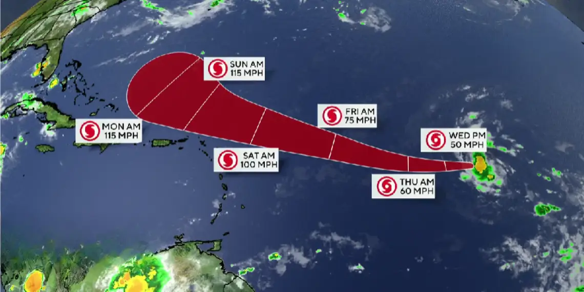
CASTRIES, St Lucia — Tropical Storm Erin is strengthening as it moves westward across the Atlantic, with forecasters expecting a turn toward the west-northwest by Thursday night. On its current track, the system is projected to pass near or just north of the northern Leeward Islands over the weekend, according to the Saint Lucia Meteorological Services.
At 5 a.m., Erin’s center was located near latitude 16.5 North, longitude 41.9 West, about 1,256 miles east-northeast of Saint Lucia. The storm is moving west at around 20 mph (31 km/h), carrying maximum sustained winds near 45 mph (75 km/h) and higher gusts. Meteorologists expect gradual strengthening, with Erin likely becoming a hurricane by late Thursday or early Friday.
Local weather conditions in Saint Lucia
Residents can expect partly cloudy skies today, becoming cloudy at times with a few showers, as light to moderate easterly to northeasterly winds persist. Winds will average 14 mph (22 km/h) from the east-northeast over the next 24 hours.
At Hewanorra Airport this morning, the temperature was 27°C (81°F) with relative humidity at 77 percent. Winds were from the east at 16 mph (26 km/h). Only a trace of rainfall was recorded in the last 24 hours, bringing the August total to 44.9 mm. Last night’s minimum temperature was 26°C (79°F). Sunset is at 6:26 p.m., and sunrise tomorrow will be at 5:50 a.m.
Marine and tide conditions
Seas within 25 miles (40 km) of Saint Lucia will be slight to moderate, with wave heights between 3 and 5 feet (0.9 to 1.5 metres). In Castries Harbour, high tide occurred at 6:26 a.m. and low tide will be at 12:04 p.m. In Vieux Fort Bay, high tide is at 7:33 a.m. with low tide at 1:31 p.m.
Regional forecast
Similar weather is expected across the Lesser Antilles, with partly cloudy skies turning cloudy at times and scattered showers likely. The Atlantic High-Pressure System will continue generating light to moderate winds from the east to northeast, carrying occasional patches of clouds and rain.
Tropical weather outlook
Forecasters are urging residents across the Eastern Caribbean, especially in the northern Leeward Islands, to monitor Erin’s progress closely. Although Saint Lucia is not currently in the storm’s forecast path, shifts in track or intensity remain possible. Regional effects such as increased swells or passing showers could occur as Erin moves closer to the islands.
For ongoing tropical weather updates and storm tracking, follow Unitedpac St Lucia News.


